RIFUGIO CARBONETTO di Caula Andrea
P.IVA 03552080040 - C.F. CLANDR81C07D205N
CIR: 004079-RIE-00003 – CIN: IT004079B8MUQDGFVR
Località Giàs Cavera, Vallone dell’Arma - 12014 - Demonte - CN -
Seguici su:
Find Us
By car, by motorcycle or by bike:
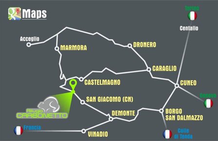
The refuge is located in Arma valley at Km 17 of the road that connects Demonte to the Colle di Fauniera.
Arma valley is a side valley of the huge Stura valley and it is part of Cottian Alps.
The Carbonetto refuge can be reached from the Grana valley, across the Colle di Fauniera (also called Colle dei Morti), and from the Maira valley, across the Colle delle Esischie.
It is always better to ask the owner about the opening of the road
By foot:
- from Castelmagno, across the colle di Viribianc (paths R5 e P11)
- from Vinadio, across the colle di Serour (paths P06 e P12)
- from Sambuco, across the colle di Valcavera (path P34)
- from Demonte, across the colle di Pera Puntua (path Lou Viage)
- from Rifugio della Gardetta, across the colle di Valcavera (ex military dirt road)

GPS coordinates:
Latitude 44.370446
Longitude: 7.152186
